
Exploring the Celestial Mountains (Tian Shan) in Kyrgyzstan: Tosor Pass, Arabel & Engilchek
All the information you need to explore the Tian Shan by 4x4, van, motorcycle or bicycle
At first glance, Kyrgyzstan looks like a jumbled mass of mountains tangled up in every direction. In fact, the country is crossed from east to west by the Tian Shan mountain range or "Celestial Mountains", whose peaks rise above basins and valleys where human activity is concentrated.
In this article, we focus on the central part of the Tian Shan that can be explored by motorcycle, 4x4 or bike, including the Tosor and Arabel passes and the ghost town of Engilchek.
- If you're planning a trip to Kyrgyzstan by van, 4x4, motorcycle or bicycle, our book EXPLORE KYRGYZSTAN will be a great help.
- If you'd like to rent a vehicle (4x4, van, motorcycle or bicycle) in Kyrgyzstan, you'll find our recommendations here.


Exploring the Celestial Mountains (Tian Shan) in Kyrgyzstan
Kyrgyzstan's altitude ranges from 401 m to 7,439 m at the summit of Pobedy Peak, the country's highest point! Over 90% of Kyrgyzstan's territory lies above 1,500 m and 41% above 3,000 m, making it a very mountainous country and a veritable water tower for the region, with almost 7,500 km² of glaciers.
The country is crossed from east to west by the Tian Shan range, which stretches over 2,000 km through Uzbekistan, Kyrgyzstan and Xinjiang province in western China. In this article, we'll focus on the central Tian Shan, which lies to the south-west of Lake Issyk-Kul.
The Celestial Mountains are mainly the domain of mountaineers and hikers, but it's also possible to explore these incredible landscapes via small mountain trails, provided you're well-informed! Most of the routes to and through these mountains are old tracks dating back to the USSR, and require off-road vehicles (trail bikes, 4x4s, mountain bikes). If you have a 2x4 vehicle, you can reach the Arabel valley and the Kumtor gold mine (track 07 in the EXPLORE KIRGHIZISTAN book) or the town of Engilchek (track 10 in the EXPLORE KIRGHIZISTAN book).
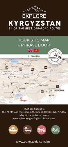
The map below shows the various roads in the Issyk-Kul region, including the tracks in the book EXPLORE KIRGHIZISTAN. This A2 folding card is available here.

Tosor Pass (3,893 m)
The 3,893 m-high Tosor Pass lies in the Terskey Ala-Too mountain range. The trail to the Tosor Pass offers magnificent views of the Issyk-Kul basin, before dropping down into the green and picturesque Uchemchek valley. It's in this fascinating mountain setting that you can discover the sparkling blue of Lake Teshik-Kul on foot, before tasting the comforting hot springs. A challenging trail for experienced adventurers!
Don't underestimate the difficulty of this trail, whose condition varies greatly from year to year. You'll encounter many difficulties: fords, deformations, mud, stones, etc.
- If you're driving, 4-wheel drive is compulsory, and off-road tires will be a great help. Make sure your tires are in good condition, and don't set off if you don't have a spare. If you get stuck in the mud, remember to unload the vehicle or deflate your tires slightly.
- If you're on a bike, you'd better have good tires and suspension, but the scenery will be well worth your efforts.
- On a motorcycle, your main difficulty will be fording the river, which is more important in early summer. What's more, lightness will be your ally on this difficult trail.
Dhe trail runs along the Uchemchek River at the bottom of the valley. Water levels and current intensity fluctuate according to the day and snowmelt. In June or July, there will be more water than in August or September.
Depending on the year, snow cover on the pass can last until June or even July. You'll need to get all the information you need before starting the ascent to the pass.
"If you hesitate to cross a river, one solution is to sleep on the spot and attempt the crossing early in the morning when the water level is lower and the current less strong. You can find all our advice on fords and off-road driving in the book EXPLORE KIRGHIZISTAN."


Arabel Pass and Kumtor gold mine
A winding, well-maintained road leads over the Barskoon pass (3816 m) to the high Arabel valley in the heart of the Celestial Mountains. At an altitude of 3,800 m, you'll discover a mineral universe, sometimes covered by tundra, sometimes colored by sumptuous lakes. Only the high electricity pylons and the trucks supplying the immense Kumtor gold mine betray the presence of man.
Although access to the gold mine is forbidden, it is possible to walk along the western slopes of the Ak-Shyrak massif, where sumptuous glaciers can be seen. Be careful: beyond the gold mine, only off-road vehicles can pass. See track 7 in the book EXPLORE KIRGHIZISTAN.
"A thousand years ago, long before this road was built, caravanners and their silk cargoes passed through the region on their way to China. It was also here that explorers of our century such as Ella Maillart and Sylvain Tesson travelled on horseback."


After a taste of this world of ice and rock in a unique end-of-the-world atmosphere, the most experienced and well-equipped can reach the verdant Burkhan valley via the Arabel pass (3,837 m). Filled with free-roaming horses and dotted with white yurts, the Burkhan Valley offers an authentic experience of nomadic life.
Beware: these landscapes must be earned! Beyond the Col d'Arabel (3,837 m), the trail becomes difficult. because of the tight switchbacks, numerous fords, isolation and poor condition of the track. In particular, it provides access to Naryn.
One of the most difficult parts of this trail is the steep descent into the Burkhan valley (or ascent if you're coming the other way). The switchbacks are very tight and the track is covered with gravel. Control your speed. If your steering angle is insufficient, you'll have to make the turn in two stages, which can be quite technical depending on the length of your vehicle. With a suitable motorcycle (powerful and light enough), climbing is easy, but be careful on the descent and limit your use of the front brake, which could cause you to skid in the gravel. For cyclists, this track was on the programme of the 2019 Silk Road Mountain Race - a real challenge!


Engilchek or Inylchek
This isolated region bordering China is known to mountaineers the world over. It is home to the country's highest peaks, including Pobedy Peak (7,439 m) and Khan Tengri (7,010 m). Surprises such as the ghost town of Engilchek, a remnant of the USSR, and the hot springs of Kara Tash await you. The road to the town of Engilchek is easily accessible by car, but a permit is required to enter this border region with China. You can order your permit online here.
The once prosperous industrial town of Engilchek (Inylchek) is now a shadow of its former self. In the early 1980s, the Soviet Union called on many young people from Soviet countries to work in the mining industries it was developing in Central Asia. The town of Engilchek was built to house the employees of the nearby tin mine. Houses, apartment blocks, a school, a hospital and even an airfield were built to accommodate the town's 5,000 or so inhabitants. After the collapse of the Soviet Union, mining came to a halt and the town was deserted. Today, a few families still live in this ghost town, where most of the buildings have been abandoned.
Not far from the ghost town of Engilchek is the Kara Tash hot spring, which is absolutely delicious. There are two open-air pools along the Sary-Jaz river. Find out more in the book EXPLORE KIRGHIZISTAN.
An isolated and demanding trail leads to the At-Jailoo base camp. It follows the immense Engilchek valley through a wild, mineral landscape. From the camp, you can continue on foot to the Engilchek Glacier, one of the world's largest glaciers (60 km long and covering 583 km2 of ice). Please note that this multi-day trek must be organized in the presence of an experienced guide.


"If you have any questions, feel free to join our facebook discussion group dedicated to exploring Kyrgyzstan. You can also share your experience of the country and/or discover photos taken by other travellers.
If you liked this article, help us and share it with your friends!
And don't forget to pin the article on Pinterest to find it more easily ?


